The Wisconsin Towns Association (WTA) is a statewide, voluntary, non-profit and non-partisan association of member town and village governments. Towns are explicitly authorized to “[a]ppropriate money to purchase
“A statewide association providing education, legal information and grassroots legislative advocacy to empower and inspire our members to lead in their communities.”
Education
WTA provides a wide array of learning opportunities on pertinent topics for town officials. Beginning in the winter, we hold 15 all day District Meetings throughout the state. January also includes our Agriculture Community Engagement (ACE) workshops. These are one-day seminars conducted in partnership with the Wisconsin Counties Association and the Professional Dairy Producers of Wisconsin that are focused on increasing relationships and collaborative understanding of both local government and the dairy industry. During the month of May in
In addition to these regional learning opportunities, WTA staff frequently travel to provide customized education to all of the towns in a county at what we call a “county unit” meeting. Members can also access of plethora of great information in our monthly magazine, on our website, through our
Legal Information
All elected and appointed officials of member governments are welcome to contact the WTA for general legal information relayed in a one-on-one fashion by one of our three attorneys. These calls are for educational purposes only and do not constitute an attorney-client relationship. We pride ourselves on
Legislative Advocacy
WTA routinely informs legislators and agency officials at the state and federal levels about the town perspective on proposed legislation, administrative rules, and policy that impacts town citizens and government. We also attempt to influence the aforementioned actors into implementing our legislative agenda. The legislative agenda is formed by
The Town Advocacy Council is a collection of over 100 leading towns that is governed by a
The TAC not only sponsors the legislative listening sessions noted above and special lobbying related workshops
At the federal level, WTA partners with thousands of other towns in many other states through the National Association of Towns and Townships (NATaT). NATaT works through its Board of Directors and federal lobbying team to influence Washington lawmakers. The WTA Executive Director is currently one of seven board members that govern NATaT.
WTA Governance
WTA is governed by a 12 member Board of Directors. There are two Board members from each of the 6 Districts. Each District is comprised of approximately the same number of county units, which are a collection of all of the member town and village officials in each county. Each county unit elects a county unit chair that represents that county’s towns and villages in electing the two Board members from each District. The Board elects their own leadership.
WTA Membership
Any Wisconsin Town or Village is eligible for membership in the WTA. Individual members include town chairpersons and supervisors and elected or appointed clerks, treasurers, or clerk/treasurers combined (who are residents of a town or village in the county). The following town officials can become Class A affiliate members: administrators, staff planners or zoning administrators; planning commission members; firefighters; law enforcement; sanitary district commissioners and sanitary district administrators; highway superintendents; election board workers and poll workers; sanitarians; building inspectors; former elected town and village officials; elected assessors; deputy officers; park commissioners; staff accountants/bookkeepers; elected and appointed county officials; and elected constables. Town vendors and other partners can become Class B affiliate members, such
WTA Vision & Values
The vision of the WTA is:
“A respected, collaborative association that provides the keys to protect and engage the power of town decision making and unlocking the potential of democracy.”
This one sentence summarizes how by providing education, legal information, and legislative advocacy we strive to provide the keys to town officials so they can leverage the power of their very own local decision making. It is this local decision making, not mandates from some far away government in Madison or Washington, which the founding generation knew was critical in unlocking the potential of democracy.
Our values are summarized as:
Character – Doing the right thing and fixing the wrong.
About the Logo
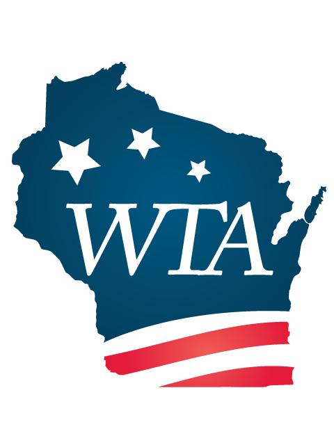
Wisconsin:
We are a statewide association.
Red:
The color red recognizes the roots of the Native Americans and pioneers that coined our state’s name. “Wisconsin” comes from a Miami Indian word “Meskonsing”, meaning “a river runs through a red place”. Without the success of a diversity of ancestors over many centuries, towns could not be successful today.
WTA:
This acronym is tilted forward, communicating that the association is moving ahead and leading. The “W” is connected to the “T” which is connected to the “A”. Wisconsin’s success is intricately connected to the success of the people, economies, environments, and governments in towns. The success of towns is dependent upon and connected to the success of the association.
Red, White, and Blue:
Collectively, these colors remind us of the flag of the United States of America and that towns are part of something bigger. The colors of the flag are consistent with the colors of the Great Seal of the United States of America that Congress specifically noted as having great symbolic meaning. White signifies purity and innocence; red, hardiness and valor; blue, vigilance, perseverance, and justice. Town officials are hardy, salt of the earth people who have pure intentions to unlock the power of democracy and will vigilantly persevere in the perpetual battle to implement our founders’ vision.
Three Stars:
The founders’ vision is captured in the three stars, which together have two meanings. First, they communicate towns’ role in a federal republic. The founders’ intended for the federal government to have limited powers (the smallest star) and for state governments to have more authority and be the laboratories of democracy (the medium star). One authority of the state was to create